Kenya (Nairobi)
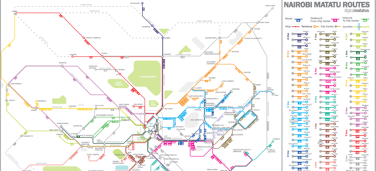
There are approximately 130 unregulated matatu lines in Nairobi. Cheap, convenient, popular – and often decorated with disco balls and Bob Marley’s image – the privately owned minibuses are the major means of transportation used by 70% of the population. However, the ad-hoc network is chaotic. Fares and timetables change randomly and finding the right stop can be difficult. The city’s streets are congested as most services run through the centre and the road network has not kept pace with rapid growth.
Although the transit system might be informal, it is now the first of its kind to go digital, thanks to the Digital Matatus Project. Conceived at Columbia University and supported by a grant from The Rockefeller Foundation, a new transit map for the Kenyan capital is now available on Google Maps – using mobile routing applications and transit data collected by students from the University of Nairobi, who rode every single route using an app that collected data, and corroborated findings with local knowledge of routes and road signs. The data, apps and maps are open to the public and free of charge, so passengers can plan journeys on their smartphones.
As the world’s third fastest growing economy, Kenya’s mobile and internet penetration are among the highest in Africa at 83% and 58% respectively of the 44.35 million population. Digital Matatus show how omnipresent mobile phone technology – combined with digital mapping and satellite monitoring – can improve essential infrastructure and services in developing countries. Extreme poverty and challenging environmental conditions are often tied in some way to cities’ transport sector when it is unmanaged. With Nairobi providing this huge first step, other African low-income cities such as Kampala, Accra, Lusaka, and Maputo are already in discussion with researchers to map their informal mass transit systems.
Adapted from a piece by Michael Zahn for Futures Centre. Read more about mixtape activism on Nairobi’s matatus.
Project leader
Sarah Williams, Assistant Professor of Information Technology and Urban Planning, Massachusetts Institute of Technology (MIT), Dan Orwa and Peter Waijanjo, University of Nairobi
Support the Atlas
We want the Atlas of the Future media platform and our event to be available to everybody, everywhere for free – always. Fancy helping us spread stories of hope and optimism to create a better tomorrow? For those able, we'd be grateful for any donation.
- Please support the Atlas here
- Thank you!